Poster: Adaptation lessons from rural communities in Puerto Rico and the US Virgin Islands after hurricanes Irma and Maria: Summarizing challenges and strategies in agriculture and forestry working landscapes
Overview
Puerto Rico and the US Virgin Islands, both US territories in the Caribbean, have been subject to compounded shocks after the brunt impacts of the 2017 hurricanes Irma and Maria. Those impacts have been amplified by local vulnerabilities and island characteristics.
Understanding how different communities and societal sectors navigate disruptions in the built and natural environments is crucial for fortifying adaptation and mitigation efforts.
Poster: Puerto Rican Farmer Households’ Food Security After Hurricane Maria: Rethinking Metrics
Overview
Islands are uniquely vulnerable to extreme weather events and food insecurity and have additional response challenges. Farmers have a key role in producing domestic food, which can safeguard food security when food importation may be challenging. Nevertheless, in the context of disaster, farmers themselves may be vulnerable to food insecurity.
Strengthening farmers’ adaptive capacity could safeguard their livelihoods, and thus support local agricultural production and food security. Understanding how people navigate disruptions in the built and natural environment is crucial for better understanding food security outcomes in the context of disasters. Future studies should incorporate mixed-methods and integrate structural variables for a more nuanced understanding.
Fact sheet: Help us record drought conditions through the CMOR tool
Overview
The Condition Monitoring Observer Reports on Drought (CMOR-Drought) is a tool that allows citizen scientists to submit observation reports relating to drought, which are presented in a map that can be used to view and access submitted information and attachments. The tool is provided by the National Drought Mitigation Center (NDMC) in partnership with the National Integrated Drought Information System (NIDIS). The USDA Caribbean Climate Hub collaborates with NDMC to make the tool and promotional materials available in Spanish. Your reports help us understand how drought is affecting local conditions. They appear on a map. The U.S. Drought Monitor (USDM) author may consult the CMOR map to help identify areas that need more attention. The USDM triggers drought responses, including the USDA Livestock Forage Disaster Program and Internal Revenue Service tax provisions. State agencies, including emergency management and public safety, may also make use of maps to know where to direct assistance.
Poster: Caribbean Drought Learning Network
Overview
Drought poses a significant challenge to resource managers in the Caribbean. In Puerto Rico and the Virgin Islands, limited water storage capacity, aging water infrastructure and primarily rain-dependent agriculture make the territories particularly vulnerable to drought. While many entities work to monitor, research and communicate about drought, no overarching framework previously existed to facilitate knowledge-sharing between them, and drought-related initiatives tended to be siloed by entity, with little synergy among efforts. To better leverage existing knowledge and initiatives in the region, the USDA Caribbean Climate Hub worked with partners from the National Drought Mitigation Center, NOAA National Integrated Drought Information System, NOAA National Weather Service and other local partners to initiate the Caribbean Drought Learning Network (CDLN). The recently established CDLN links climate researchers, service providers, advisors, managers, and producers in a peer-to-peer network to strengthen collaboration and communication in drought research and management.
Climate Change in the Caribbean
Overview
Regional climate models project accelerating sea level rise and a warmer, drier and more variable climate, with frequent droughts and intense storm events. It is projected that variable rainfall patterns will aggravate current problems of water scarcity and soil erosion. Recently, Puerto Rico and the U.S. Virgin Islands experienced devastating hurricanes as well as extreme droughts followed by heavy rain events that severely affected livestock and agriculture. In addition, climate changes in other regions of the world have an impact on food supply and food security in the Caribbean, for instance, given an increase in the costs of food production and the price of food. These global and local factors influence the decisions regarding the use and management of agricultural and forest lands.
Download Climate Risks in the Caribbean (900 KB)
Hurricane preparedness and recovery: perspective of agricultural advisors in Puerto Rico and the US Virgin Islands
Overview
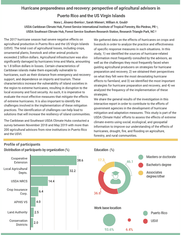
The 2017 hurricane season had severe negative effects on agricultural production in Puerto Rico and the US Virgin Islands (USVI). The total cost of agricultural losses, including crops, ornamental plants, livestock and other animal products exceeded 2 billion dollars. Agricultural infrastructure was also significantly damaged by hurricanes Irma and Maria, amounting to 1.8 billion dollars in losses. Certain characteristics of Caribbean islands make them especially vulnerable to hurricanes, such as their distance from emergency and recovery support, and dependence on imports and tourism. These characteristics increase the vulnerability of island societies in the region to extreme hurricanes, resulting in disruption to the local economy and food security. As such, it is imperative to evaluate the most effective measures that mitigate the effects of extreme hurricanes. It is also important to identify the challenges involved in the implementation of these mitigation practices. The identification of challenges can help lead to solutions that will increase the resiliency of island communities.
Note: This is an interactive factsheet and not a PDF.
View the interactive factsheet Hurricane preparedness and recovery: perspective of agricultural advisors in Puerto Rico and the US Virgin Island.
What is the U.S. Drought Monitor
Overview
The U.S. Drought Monitor (USDM) is a map released every Thursday, showing parts of the U.S. that are in drought. The map uses five classifications: abnormally dry (D0), showing areas that may be going into or are coming out of drought, and four levels of drought: moderate (D1), severe (D2), extreme (D3) and exceptional (D4). It is produced jointly by the National Drought Mitigation Center (NDMC) at the University of Nebraska-Lincoln, the National Oceanic and Atmospheric Administration (NOAA), and the U.S. Department of Agriculture (USDA).
Supporting the Revival of Agriculture and Silviculture in Puerto Rico and the U.S. Virgin Islands after Hurricanes Irma and Maria
Overview
In response to the damages to the agricultural and forestry sectors caused by Hurricanes Irma and Maria, the Caribbean Climate Hub has undertaken the following objectives:
- Compile and disseminate information about the state and federal programs that provide disaster assistance for farmers and landowners in order to support rural communities;
- Document the effects of Hurricanes Irma and Maria on agriculture, livestock, and forests by collecting photos and videos;
- Collaborate with agencies and non-governmental organizations currently evaluating damages to share information and assist with data analysis;
- Develop a comprehensive assessment of damages,losses, needs and opportunities for recovery within the agricultural and forestry sectors in Puerto Rico and the U.S. Virgin Islands.
Disaster Assistance for Farmers
Overview
Which USDA disaster assistance programs are available?
The USDA provides various services and programs for disaster-affected producers. The programs listed below are managed by different federal agencies. Each program has different requirements for eligibility. Contact the agency that manages the program that interests you to verify whether you are eligible for assistance. The contact information for your municipality is located in the following pages.
How to Salvage Fallen Trees after Hurricane Maria
Overview
How can we benefit from this valuable resource ?
Hurricanes Irma and Maria have left thousands of fallen trees in our streets, yards, farms, and forests. One of the most important tasks after a hurricane is to clear the streets and remove downed trees. However, this also presents an opportunity to take advantage of the high economic value that can be recovered by salvaging the tropical wood of our downed trees.
How to Disinfect Water After a Disaster
Overview
After a natural disaster, it is often the case that the water is not suitable for consumption. Please check with your local authorities to find out whether your water is safe.
If you do not have access to bottled water, there are two simple options to disinfect your water:
- Boil the water for 1 minute
- Disinfect the water with household chlorine bleach
Keep Valuable Wood out of the Waste Stream!
Overview
Please consider salvaging fallen trees that are economically valuable.
- How to store logs?
- Which trees are economically valuable?
The Basics: Climate Change
Overview
What is “CLIMATE”? The term climate refers to the larger, long-term systems in which weather takes place. The climate of a place includes things like temperature, rainfall, and wind averaged over a long period of time, usually 30 years.
- Climate Projections for Puerto Rico and U.S. Virgin Islands
- Potential Climate Change Effects, Risk and Vulnerabilities
- How does climate change affect agriculture and forestry in the Caribbean?
- I’m a farmer or forest landowner, what can I do to build climate resilience?
Climate Change Effects on Livestock & Adaptation Strategies
Overview
Dairy farming is important in Puerto Rico and St. Croix, with more than 320 dairy farms in Puerto Rico on about 50,000 acres of land that generate over 25,000 jobs. In 2014-2015, the dry season in the US Caribbean was drier than usual and this sparked wildfires, pasture shortages, and land degradation, affecting livestock production.
- Climate Projections for Puerto Rico and U.S. Virgin Islands
- Climate Effects on Livestock and Dairy
- Adaptive Strategies
- Opportunities for the livestock industry in the US Caribbean
Drought Effects on Forests and Rangelands in the US-Caribbean
Overview
Issues of water quality and scarcity are of great concern across the U.S. Caribbean. In recent years Puerto Rico and the U.S. Virgin Islands have experienced uncommonly dry weather that has caused moderate to severe droughts. In 2014-2015, severe drought in Puerto Rico required the implementation of water restrictions that affected millions of people. The summer of 2015 was the third driest period in Puerto Rico since 1898, forcing the strictest water rationing in its history. Emerging climate models for the region (Figure 1) predict an overall decrease in precipitation over the next century, but also to greater variance in seasonality and an increase in intense precipitation events1. The temporal and spatial distribution of rainfall can have profound effects on the hydrology as well as the phenology and life-cycle of trees, rangeland species, pests and pollinators. Changing rainfall patterns will mean major adjustments in how
working lands are managed by producers and planners.
Mission and Vision of the Caribbean Climate Hub
Overview
Climate change is one of the biggest challenges facing the agricultural sector, threatening food security and sustainable development. The Caribbean region is particularly vulnerable to the effects of climate change due to its geographical location and socio-economic condition. To deal with these climate challenges, we must strengthen ties of cooperation between government agencies, research institutions, community-based organizations, farmers and agricultural entrepreneurs.
USGS and Climate Hub Drought in the U.S. Caribbean Series
Impacts on Coastal Estuary Ecosystems
Overview
The topography of Puerto Rico and the U.S. Virgin Islands is characterized by steep terrain and short distances to the sea. This means that freshwater runs off the islands quickly, coming into contact with seawater in coastal estuaries. The physical characteristics of estuaries change as the tides rise and fall, creating a wide range of habitats that support diverse plants and wildlife, including economically and culturally important native species such as cetí and land crabs, as well as game fishes such as snook and tarpon.
Impacts on Crops
Overview
Agricultural production in Puerto Rico and the U.S. Virgin Islands is important for the region’s economy, food security, and rural livelihoods. Farms in the region are mostly small-scale and cultivate a wide variety of crops including plantains, vegetables, coffee, hay, and ornamental plants. Small-scale farms of 10 acres or less are much more common in the U.S. Caribbean than in the continental U.S. While the variety of crops these farms provide is vital to the region, smaller financial margins can make them more vulnerable to climate-related hazards.
Impacts on Freshwater Ecosystems
Overview
Healthy and functioning freshwater ecosystems are needed for successful conservation and management of native fish and invertebrate species, and the services they provide to communities across the U.S. Caribbean. Yet streams, rivers, and reservoirs are vulnerable to the effects of extreme weather, urbanization, energy development, and other environmental and human-caused disturbances.
Impacts on Livestock
Overview
The production of dairy and beef is important for food security and the economies of the U.S. Caribbean. The dairy industry is the leading agricultural sector in Puerto Rico, contributing about 22% of the total agricultural income. Region-wide, beef and dairy production generate over 25,000 jobs and occupy more than 50,000 acres. In the U.S. Virgin Islands, cattle production has been declining in recent years due to higher insurance costs and natural disasters, while sheep and goat production has increased.
Impacts on Tropical Forest Ecosystems
Overview
Forests in the U.S. Caribbean are spectacularly diverse, with more than 500 native tree species in Puerto Rico alone. These forests and trees provide many services to the region’s 3.5 million people, including watershed and coastal protection, economic benefits from fruit and wood, cooling in urban environments, and improved water quality, recreation, habitat, and biodiversity protection. Caribbean forests range from coastal mangroves and dry forests, to rainy cloud forests on the mountain peaks. They have been shaped by frequent natural disturbances such as hurricanes, drought, flooding, landslides, and wildfire.
Infographics
Agricultural Conservation Practices for Climate Risk Reduction
Overview
The effects of climate change have been observed on agricultural lands in the Caribbean. Climate change effects include shifts in temperature and precipitation, which can manifest as water scarcity or excess, above normal temperatures, sea level rise, as well as frequent tropical storms. However, the implementation of conservation practices on agricultural lands helps to significantly reduce the effects of climate change.
In order to describe the existing connection between the best conservation practices and the mitigation of climate change effects, the USDA Caribbean Climate Hub designed the following infographic.


Follow Us!